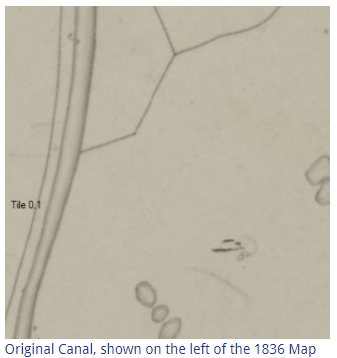
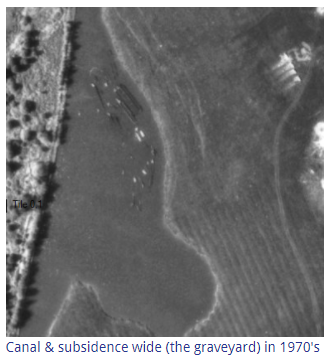
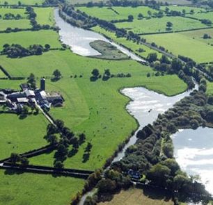
The site Ripple Developments chose for its marina development consists of two areas of water (canal wides) and adjacent land, as seen in the aerial photo below left. The original canal line was straight when built (above left), but the offside bank, in two locations adjacent to Higgins Lane Farm, sank over time due to brine subsidence. The canal water flooded onto the private farm land, removing it from agricultural use and resulting in a financial loss to the farmer.
The landscape is effectively man made, from the unplanned impacts of an industrial process known as wild brine extraction, now abandoned due to the uncontrolled subsidence. Brine extraction continues on a smaller scale but now in a controlled way, in specific defined locations although this site can still be affected by natural underground flows.
The Trent & Mersey Canal corridor was locally designated as a conservation area in 2000, in recognition of its unique features, tranquil environment and adjacent landscape.
We acquired the two wides (seen top and centre in the aerial photo above left) from their owner in 2008.
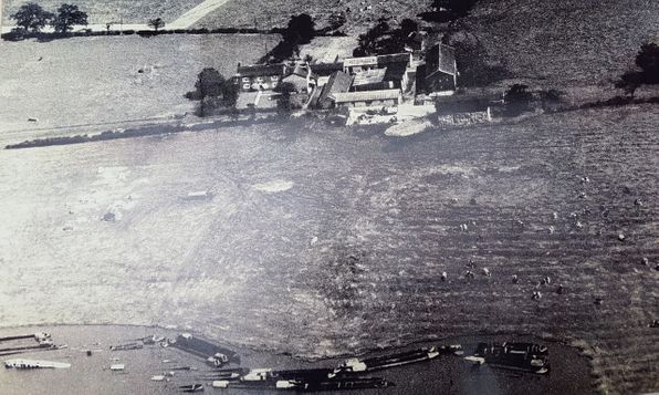
The black and white photo above (bottom right) shows old work boats said to have been abandoned by British Waterways, on the area of land/water belonging to Higgins Lane Farm at the time. They were left there between 1946 and 1976, when they were eventually removed after health and safety concerns raised by the farmer over children playing on the decaying boats. The removal was carried out under the supervision and guidance of Ellesmere Port Boat Museum. The landowner was advised by BW that he could fill in the wide if he wished to. Subsequently, the site was used by the land owner for private mooring and fishing until we acquired it in 2008.
The depth of the canal in places is over 4m to original bed, overlain by deep silt. The canal bank on the towpath side has been raised over the years to maintain it above the canal water level, as the surrounding ground sank. The raised towpath now separates what would otherwise be one large lake, with the canal navigation running through it.
In terms of planning consent, we discussed the potential to develop the site into a marina with the then Vale Royal Borough Council and British Waterways in 2003. Following a positive response we presented our proposals formally to BW in 2004 and got their approval for our development in March 2005. We then presented our development proposal to the strategic planning unit, set up by the local authority to avoid applicants wasting their time on large projects... (risking financial commitment) that were unlikely to obtain consent. Our proposal was given the green light to proceed in July 2005. Despite planning consent being eventually obtained in 2008, various third party issues conspired to prevent the family vision taking shape until 2017.
However, unfortunately the new ill advised HS2 2b proposed realignment route is set to run right through the middle of the two wides, in the conservation area and will cut the wides in two if the proposal comes into being, ironically through the section of land Vale Royal Borough Council said was the most important part of the site not to develop due to its rather unique topography. Hopefully the local council still hold that view and properly object to the huge development proposed in open countryside and a conservation area - too large for the receiving environment perhaps! The eventual outcome of HS2 Phase 2b is unknown. Those on the original route were seemingly blighted for years for nothing, so who knows how the revised proposal will transpire or what impacts it will have in the short and long term.
Our location is well positioned, on the Trent & Mersey Canal, to maximise the choice of canal cruising routes in the North West.

Oakwood Marina © 2024 | All Rights Reserved |
Privacy Policy | Built By
